House, Senate redistricting committees get first look at draft congressional maps

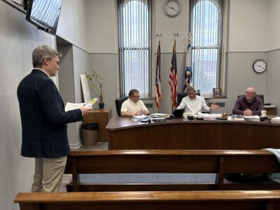
Photo Courtesy/WV Legislative Photography REDISTRICTING — Delegate Caleb Hanna, R-Nicholas, reviews proposed West Virginia congressional district maps.
CHARLESTON — Members of the West Virginia Legislature’s two redistricting committees reviewed some of the first-draft maps, Thursday, laying out what dropping from three congressional districts to two could look like.
The House Redistricting Committee met Thursday morning at the Capitol for its first organizational meeting.
While future draft maps will be uploaded 24 hours before the start of future meetings, committee members were shown six proposals for dividing West Virginia into two congressional districts.
West Virginia has had three congressional districts since the early 1990s, originally having six districts and an at-large district before population loss dwindled the number of districts down to three. After the 2020 Census, West Virginia’s population dropped to 1,793,716 and resulted in the loss of another district.
Lawmakers will need to draw two congressional districts with about 900,000 residents each with as little deviation in population as possible between the two. Both districts also will need to be as compact as possible, though the state’s two panhandles make that tough.
“We have to have as close to parity between the two districts as we can,” House Redistricting Committee Chairman Gary Howell, R-Mineral, said. “We’re looking at not splitting counties, keep the number as low as we possibly can and keep it compact. As a state, we drive everywhere. In one of the maps, they put Kenova in with Harpers Ferry. That’s probably a seven-to-eight-hour drive from one end to another. Does that meet the definition of compactness? Probably not.”
The six maps presented to House members split the state between north and south, east and west, with some dividing the state diagonally. Five out of the six maps would put the two fastest growth areas of the state – Morgantown/Monongalia County and the Eastern Panhandle – in the same district.
“Really, the growth areas shouldn’t be a concern to us,” Howell said. “That’s just natural. You have areas that grow and areas that change and they’re not always the same areas. That varies from decade to decade. One is able to capture the economic growth and the other one isn’t.”
Assuming any of the current members of the House of Representatives run for re-election in 2022, four of the six maps would put 1st District Congressman David McKinley, a Republican from Ohio County, and 2nd District Congressman Alex Mooney, a Republican from Jefferson County, against each other in a primary. One map would put McKinley and 3rd District Congresswoman Carol Miller, Republican from Cabell County, against each other in a primary. And one map would put Mooney and Miller into a primary.
“We’re trying to look at the most objective criteria we can, then come up with the map that best fits,” Howell said. “I guess technically, everybody would be a non-incumbent because they’re in new districts. Can they drive the district and meet the people and serve the people of that district reasonably well without spending a bunch of time in the car driving? They need to be out there among their constituents hearing what they need.”
Later Thursday afternoon, the Senate Redistricting Committee met for its second meeting. It held its first organizational meeting last week.
In accordance with its rules, draft congressional maps were made available on the Legislature’s redistricting web page 24 hours before Thursday’s meeting.
The committee looked at 12 draft congressional redistricting maps. Though no maps can be approved until Gov. Jim Justice calls a special session for redistricting, the committee focused on two similar maps proposed by Sen. Dave Sypolt, R-Preston, and Sen. Glenn Jeffries, D-Putnam.
Both maps used I-79/I-68 as a guide, with Mason, Putnam and Kanawha counties making up the southern border of a new 1st Congressional District along with everything west of Tucker, Barbour, Upshur, Webster, Nicholas and Fayette counties.
“Although I am somewhat partial to my map, I would tell you that I like Jeffries’ better and would support that map. They’re very similar,” Sypolt said. “Not being disparaging about any of the other maps, but (other maps) each place the growth areas of the state together in one district, which causes a logistic problem going forward for the next 10 years. If those areas continue to grow, you’re going to see a change in population between the two districts that is disproportionate.”
“The Interstate 79 corridor is a divide that keeps the Martinsburg area, the Eastern Panhandle area, divided from the Morgantown area,” Jeffries said. “That way, you have two areas that are growing that can filter the southern parts of West Virginia.”
The two maps drew criticism from two southern West Virginia lawmakers.
Sen. Eric Tarr, R-Putnam, raised concerns about splitting up Cabell County from Putnam and Kanawha counties. In his own draft map, Tarr put both the Eastern Panhandle and Northern Panhandle together.
“Because the Eastern and Northern panhandles have had a lot of population growth. If the state were split such that it was the Northern Panhandle in one district and the Eastern Panhandle in another district, the southern part of the state would probably never see a person in Congress,” Tarr said.
“A lot of the southern part of the state is very Kanawha-centric.,” Tarr said. “People identify with the Charleston area. It’s where they travel for business and a lot of times where they travel for shopping or traveling for anything that has to do with the services of the state. There’s a lot of bedroom communities that are around Charleston as well. The Putnam County/Teays Valley area where I live is one of those areas.”
“To me, it’s fundamentally important that Cabell County and Putnam County and Kanawha County be in the same congressional district,” Woelfel said. “There are many commonalities that exist. As far as economic development, we’re viewed by many as a single unit. The federal government, in many ways, treats us as a single unit. I just want to suggest to everyone that southern West Virginia has a long way to go, and we see ourselves as part of southern West Virginia.”
The draft maps can be found at the West Virginia Legislature’s website where people can view the maps, submit their own maps or comment on the proposed maps. The address is
https://www.wvlegislature.gov/redistricting.cfm?utm–source=pocket–mylist
(Adams can be contacted at sadams@newsandsentinel.com)
Local News
With Jefferson County’s 2026 budget finalized, work starting on 2027 plan
Weirton Parks to host annual Easter Egg Hunt

Brooke teen leads statewide effort for foster youth
Today’s birthdays
March 25 Jeannie Roberts, Mingo Junction March 26 Pat Pesta, Smithfield March 27 Audrey “Bobby” ...
Community Briefs
Mingo Council adjusts meeting schedule MINGO JUNCTION — Village Council has had to adjust its meeting schedule ...